Thursday, November 26, 2015

Dubois (WY)

After breaking our roadside camp in Lander, we continued westward towards Yellowstone and decided to make a short stopover in “The Most Remote Town of the Lower-48”—Dubois, Wyoming.  Situated at least 75-miles from the nearest Red Box video rental (the truest measure of "cosmopolitan remoteness”), Dubois is an old “cowboy town” that is reluctantly transitioning into a destination location.


We followed the Wind River to the Longhorn Ranch, and parked our rig under the aged canopy of sap-drizzling cottonwoods.  The Longhorn Ranch is a wonderful, full hook-up RV resort that has a “very fishable” stretch of the Wind River on two sides of the property.  We initially chose this location—80-miles from Jackson (WY)—as a place to “paper scout” our final push into the Yellowstone area.  We headed to the Dubois National Forest Service office to procure some regional maps for potential “boon-docking” locations.  The NFS folks were incredibly helpful, friendly, and full of extremely valuable info regarding the local wildlife.

Wind River frontage at The Longhorn Ranch
Although Dubois is geographically remote, it borders thousands of acres of wilderness.  This feature gives the township an increased risk of dangerous wildlife encounters; to include moose, wolves, and grizzly bears.  Although there are other animals in the vicinity, these three account for the majority of human/wildlife encounters that result in negative outcomes.  The NFS folks gave us a crash-course in preparing ourselves for camping in-the-wild, and also gave us info on the most recent local encounters.

  • Moose: Big and unpredictable.  May run from you.  May stand and stare at you.  May charge and attempt to River-dance on you.  Keep a distance…especially if you see a cow/calf pair.  Moose cows perceive dogs as a coyote/wolf threat to their calfs, so hiking with dogs can actually incite aggressive behavior.
  • Grey Wolf: Reintroduced into the area and the population has continued to thrive.  When packs are forming in the Fall, they “clear” their territory by eliminating all other non-pack Canis species…including domestic dogs.  Horseback trail-riders have had their dogs—following UNDER the horses—completely decimated by packs who blitz through the equestrian group to eliminate their domestic Canis cousins.  
  • Grizzly Bear: Apex carnivore in this region that is a threat to all animals—including humans.  Several encounters have been locally reported; from narrow escapes to being ingested.  Bear spray, group travel, and heightened situational awareness are necessary to prevent injury and/or death.  
After purchasing our NFS maps, we headed to the local store to pick-up a couple cans of bear spray.  The $38 price stung a bit, but the thought of my final resting place being in a steaming pile garnished with wild berries helped me part with my available cash.  

A quick look at our newly acquired maps showed numerous roads leading into BLM land and onward towards the wilderness.  We turned onto Horse Creek Road and headed northward into the wild.  After a few miles of pavement, the road narrowed and turned to washboard dirt/gravel of the remaining 26-miles.  As the road diverged away from Horse Creek and began the switch-back ascent into higher elevations, we focused on finding a boon-docking spot within the remote landscape.  With our eyes focusing on the ever-expanding panorama that each passing ridge-line provided, we were suddenly caught off-guard.  Charging up the hill from the passenger side of Hank was a juvenile bear.  It was on a collision course with our truck until I locked-up the brakes; at which time it ran across our path by a few feet and proceeded up the opposite hillside.  Jaw-dropped at the event that just transpired, we pulled-out our recent bear spray purchase and removed the hermetically sealed package.  We were in the wild.

End of the line: Horse Creek Road terminates at Wiggins Fork Creek and the wilderness beyond 
Horse Creek Road terminates at Twin Cabin Campground; a NPS recreational tract that boarders  Wiggins Fork Creek and an expansive uninhabited wilderness that continues towards the southeastern boundary of Yellowstone National Park.  With the adjacent unspoiled wilderness and a high-elevation cut-throat trout source; grizzly bears are frequently seen.  We found several potential boon-docking locations along Horse Creek Road, but the narrow and weathered road—coupled with the healthy bear & wolf population—made us rethink our boon-docking plans.

"Forever Views" of distant mountains and glaciers from Bear Basin
Ten miles east of Dubois down Highway 26 is East Fork Road; another long (24-mile) dirt/gravel road that terminates at Bear Creek and Bear Basin.  As the road conditions worsened, the views exploded; revealing distant mountain chains that are home to snow-capped peaks and glaciers. This is where we discovered a few of the most breath-taking (established) boon-docking locations, but the rutted road coupled with all geological features having “Bear” in the name, made this location a no-go.

A few miles southeast of the Longhorn Ranch is another NFS road that provides access to a trio of lakes; Torrey Lake, Ring Lake, and Trail Lake.  This aquatic trifecta sits at the northern most end of the Wind River Range, and just east of Bridger-Teton National Forest.   We drove this much shorter dirt/gravel trail to the terminal point—a trailhead that leads to a glacier and “Bomber Lake,” named after a WWII aircraft that crashed into the high-mountain lake.  We found a beautiful lakeside boon-docking location next to Ring Lake and readied our plans to relocate from The Longhorn Ranch.  

Front door view from our lakeside digs
The campsite was pseudo-level—sitting on a narrow plot with large rocks and established trees.  Hank gently eased Glory into the pre-existing “tire ditch” (somebody else had “lowered the uphill grade”), we set up camp in relative solitude. 

Time to fish.

Fresh, grilled trout over a wild rice mix.  We'll be back to Dubois...for seconds!
The location of our new camp gave us the option of “bait casting” into Ring Lake, or fly fishing in the broad river that flowed to adjacent Torrey Lake.  The lake came alive in the twilight hours, with the large pisces population making themselves known to hopeful anglers.  After several days of throwing every conceivable fish food into the local waters, the fishing tournament was ultimately won by the local osprey—who caught trout with ease, and mockingly discarded most of their bounty on the banks below our camp.

Ancient petroglyphs decorate ancient canvass
Across from our campsite were several trails leading up to the towering cliffs above.  While I was busy waterboarding worms, she explored the geological features and caves that overlooked our camp.  It was on one of these expeditions that she discovered several ancient petroglyphs.  Dating back thousands of years, this ancient "art language" depicts important aspects of human life during an era long past.  These particular petroglyphs had only been discovered within the past few years; leaving novice archeologists with hopes of making their own discoveries.

Da Boyz in Dubois
The winds moved across the mountains, swirling with such forceful unpredictability that a modest campfire was a chore to maintain containment.  Red Flag warnings began to pop-up across the region, and scores of wildfires plagued The Great Northwest.  As the jet stream moved the burning participates from near and distant wildfires, the local visibility significantly declined.  It was too warm sequester ourselves inside a non-air conditioned RV; and there was too much dust/smoke particulates in the air to enjoy our outside space.  With no end in sight for the wildfires and our (now clinical) mild respiratory symptoms, we returned to the Longhorn  Ranch and prepared for our final push towards Yellowstone.

After purging our tanks and making reservations for our next stop, we pulled our sap-covered rig  from under the cottonwoods and headed west.  Dubois was a hidden gem that we stumbled upon by chance.  Although not known as a destination location, we made a pact to return to this wild and wonderful town.

Lettin' loose at The World's Largest Jackalope Exhibit--Dubois, Wyoming
wWw

Thursday, October 15, 2015

Sinks Canyon State Park (WY)

The Essential Sinks Canyon
With the chocks set and the utilities connected, we prepared for a few days of on-the-grid living in Lander, Wyoming.  Lander is a quaint town that has the feel of an upscale town.  The downtown area has retained the historical look, and the overall appearance is clean.  Since we had been boon-docking for a while, we needed to stock-up on a few things and this town would do the trick.  

Lander wasn’t on our original list of places to visit, but it did offer a comfortable stop-over between The Bighorn and our planned destination of Yellowstone.  Although our main focus was to head towards The Tetons, we thought we’d kick around this area and see what hidden gems we could find.  The previous 150-mile trek from the northeast had revealed mountains, canyons, dinosaur remains, and thermally driven natural hot springs.  Certainly this area had something that was notable.  We were not disappointed.

Lander sits at the southeastern end of the Wind River Mountains.  This mountain range is perhaps perhaps the most “unspoiled” area in Wyoming—to include Yellowstone.  We headed about 5-miles southeast of Lander to the Sinks Canyon State Park.  This park would be a destination anywhere east of the Mississippi River; however, with competition from nearby Yellowstone National Park and Teton National Park, it remains rather obscure.  That obscurity is a blessing to those who happen to stumble upon it.
Kristy & Buddy scouting the flora below the vertical cliff walls
From the moment you enter the steady uphill grade into the park, you are bordered by high cliffs of sedimentary rock firmly planted on a bed of granite.  These vertical cliff walls—terminating at amazingly horizontal plateaus—bring immediate images of western films where “indians” would line the high-ground cliffs prior to descending into battle on the valley floor below.  This was natural western nostalgia at it’s finest.

Popo Agie River cascading downwards and into the mountain-side "sinks"
One of the most interesting features of the park—to the point of being referred to as a “geological phenomenon”—is the “Sinks” and “Rise.”  From high within the mountains, the PoPo Agie (translated from the Crow Tribe as “gurgling river”) River flows down through the rocky, juniper and sage-laden landscape, and disappears into the side of the mountain.  Geologists have yet to map the exact course of the river as it makes its subterranean trek; but all evidence of river activity is void until it reemerges a half-mile “downstream” at pool that is currently home to hundreds of obscenely large trout.  The disappearance into the mountain (“sinks”) and reappearance at the trout pond (“rise”) is what gives this feature its name.
The Popo Agie River "Sinks" into the mountain-side...
...and reappears 1/2-mile away at the trout pond.
A few miles uphill from the Sinks and Rise sits Bruce’s Picnic Area; named after John Bruce, one of the earliest forest rangers in this area.  Bruce’s Picnic Area marks the trailhead for the Middle Fork Falls, a 1.5-mile trail that ascends 600-feet to the base of…a high desert waterfall!  With Kristy’s affinity for hiking and waterfalls, our plans were seemingly preordained.  

A herd of "Trout-zillas" frolicking in the "No Fishing Zone" at Sinks Canyon State Park
We parked in the adjacent lot, strategically jammed water bottles in cargo pockets, secured The Boy’s leashes and headed up the trail.  The pathway was rocky and dusty--a by-product of the incredibly arid environment that lay around us—and paralleled the Popo Agie River for the 3/4-mile.  These were really at contrasting opposites; with the powdery soil seemingly unaffected by the forceful river running closely adjacent.  The trail continued upward; increasing in both pitch and elevation.

Halfway up the Middle Fork Falls Trail
Although we had driven across (what looked like) relatively level terrain during our trek into Lander, we had actually been gaining significant elevation all along the way.  Lander was a “really flat” 5,400' in elevation; with the Sinks Canyon Park entrance around 6,500’.  The trailhead of the falls had us starting our hike at 7,150’, and by the time we hit the switchbacks (roughly 7,500’) we were reminded that we were “oxygen junkies.”

After slowly and steadily motoring through the switch-backs, we made our last push to the base of the falls.  Streaming down over a series of cascades, the Middle Fork Falls display their crescendo moment over a 60’ drop.  The trail continues to the upper falls area; where hikers, climbers, horseback riders and fly fishermen enjoy their favorite activities in a mountain top surrounding.

Wes & Callie taking in some views, air, and water
We tarried long enough to snap a few photos, hydrate ourselves and the hounds, and oxygenate our cells.  The sun was dipping behind the westward ridge-line and we needed to give ourselves time to hike while the light was still favorable.  The hike down was easier on the muscles, but harder on balance.  The dusty surface did not provide much of a footing for the imbedded rocks, and the ground had a tendency to give-way when you least expected it.  By the time we reached Hank, we were ready for a “dust-cutter” ourselves.  

The park was truly a diamond-in-the-rough on an out-of-the-way destination.  We appreciated both the accessibility that the well-maintained trails provided; as well as the restraint of development and keeping the park in a very natural setting.  We later found that this was the mantra of the park development plan form the very beginning: "Within the canyon walls are found unspoiled symbols of the best of Wyoming. The mountains, the river, the fish and wildlife; sage, wildflowers, aspen and pine trees, a rugged country of tranquil quiet under blue sky. The development of park facilities must accent and enhance these values. To overwhelm them with chrome plated campgrounds and concession stands would be unwise.”

Well done Lander.  Well done.

wWw

Saturday, October 10, 2015

Bighorn Basin’s Greatest Hits

As we planned our westward exit from The Bighorn, we took a look at the travel atlas to see what was a plausible destination.  We were planning our approach into Yellowstone, and the two routes that presented were towards the western entrance via Cody (190-miles), or towards the southern entrance via Dubois (270-miles).  For reasons that completely elude us to this day, we choose the longer route that took us through some of the most unrecognizable names in Wyoming.  

We broke camp from our Bighorn boon-docking site and headed westward on 16.  The day was overcast and the temperature bottomed-out at 46F when we reached the 9,685-foot pinnacle of Powder River Pass.  The western departure from the Bighorn did not provide any driving breaks as the eastern side did with its series of descents and plateaus.  The next 10-miles of driving would be an intense 8% grade with a double-hairpin switch-back at the halfway point.  Even with the transmission in a lower gear, and Hank’s exhaust brake singing baritone all the way down the mountain; we had to make an unscheduled stop at a pull-off to let the brakes cool down.  

Beyond the double-hairpin switch-back the road began to level to a manageable grade, as we rolled through the sheer canyon walls bisected by Ten Sleep Creek.  As the towering canyon walls began to shrink in size, the horizon ahead began to open up and the moderate cliffs began to show more variety in colors.  

We continued to follow the river trail—littered with sporadically parked vehicles of fly fishermen hiking down to their favorite spots—and arrived at Ten Sleep.  Ten Sleep is a small town of less than 300 and was a Native American rest stop during travels across this region.  It derives its name from the fact that it is 10-days travel—or “10 sleeps”—from this location to Fort Laramie, Yellowstone National Park, and the Indian Agency on the Stillwater River in Montana.

The geography made a sudden change, with the rocky granite being replaced by colorful worn clayish cliffs that were very similar to those across The Badlands.  With the exception of a large mountain range to our east, we could’ve easily mistaken this area for The Badlands.  This stretch of colorful pastel land continued for several miles until we crossed Big Cottonwood Creek—and suddenly it was like watching The Wizard of Oz backwards.  The pastel colors changes to dull beige with an erratic pattern of sage across the ever-flattening hills.  The horizon became increasingly large, with the largest natural shadow coming from solitary cedars making infrequent cameos.  The predominant structures were miles of power-lines extending into the barren landscape and oil wells.  This was a dusty, deserted land that would’ve been an excellent option for filming the Mad Max trilogy.

After several miles the dusty wasteland abruptly disappeared and was replaced by lush green fields of corn and sugar beets.  We had arrived at Worland.  Worland is a town of around 5,000 who make their living off oil and sugar beets.  The Bighorn River runs to the west of Worland, and if “Egypt is the gift of the Nile,” then “Worland is gift of the Bighorn River.”  The lush greenery that extends to the municipal limits sits directly in the shade of a vast network of irrigation systems.  Without this irrigation network, Worland would look like the previous 10-miles.  Probably the most unfair feature of Worland is the weather.  The summers are hot and dry, with the average high in July of 89F (record: 107F) and the average low in January of 3F (record:-50F).  There is no month where the average temperature is between 70F-80F.  Extreme living indeed!

Unable to continue westward (as the highway abruptly became a north/south option), we merged onto Route 20 and followed the Bighorn River.  The Bighorn River is a large river that enables this region to have a sustainable agricultural presence.  The long green ribbon of cropland that borders both sides of the Bighorn River provides a contrasting reprieve from the distant arid plains where irrigation has yet to reach.

After another 30-miles of southward travel we arrived at the town of Thermopolis.  Thermopolis is home to the world’s largest mineral hot spring—and unlike other “hot spring” tourist traps—this one is 100%, absolutely free.  They even have a big city park where you can soak your bones in the natural noodle bowl.  It is such a large hot spring venue that it appears to be a type of water park when entering the city from the north. With the geothermal activity bringing steamy water to the surface, and rare dinosaur artifacts discovered nearby; this place must have been really rockin’ at one time.
The Green Belt ends and the Wind River Canyon begins
With 90-miles of travel behind us, we were ready for another drastic change in the scenery; and we got our wish.  Upon departing Thermopolis, we entered the Wind River Canyon area.  This aquatic juncture—known as “The Wedding of the Waters”—is where the Wind River becomes the Bighorn River; and it serves as the eastern border of the Arapahoe & Shoshone Reservation.  The Wind River is a fast-flowing white-water river bordered by lush vegetation and steep cliffs that wind through this very windy gorge.  The highway parallels the twisting river, and in some instances goes through the adjacent mountainside.  These cozy tunnels with arched tops and a paucity of shoulder space made everyone momentarily cringe as we squeezed Glory through these narrow and unmovable passages.  One of the most impressive sights along this route are the enormous “house-sized” boulders that sit in the middle of the Wind River.  They look completely out of place until you follow the trail of scree that follows towards a place in the mountain where a large cavity now exists.  In some of these areas you can see where the highway and adjacent railroad track have been recently repaired due to the monstrous-sized boulders bring total destruction from above.  To witness an event such as that must have been both jaw-dropping and pant-staining.

Giant boulder (just right of roadway marker) rest in the Wind River
Nervous navigation through mountain tunnels
As we followed the Wind River, we came to another abrupt geological change.  The canyon opened-up to reveal a large body of water that was surrounded by a high desert plateau that stretched into the horizon.  The large body of water—Boysen Reservoir—was the result of damming the southern end of the Wind River Canyon.  Again we were looking at relatively flat terrain speckled with sage, except now we had a 300-Million gallon pond to our west.  

We followed the arrow-straight rolling highway to the crossroads of routes 20 & 26, where sits the small town of Shoshoni.  Shoshoni warrants a dot on the map—but not a large one.  The 2010 census listed the population at 649; 45 more than the census of 1910.  It is a very old town that has not had a make-over…well…ever.  .  The summers here are hot, the winters cold, and the rain scarce.  You gotta admire the moxie of folks who live in such extreme conditions and still seem to enjoy life.  Somebody should bottle that.

Twenty two boring miles southwest of Shoshoni is the “rendezvous" city of Riverton.  I’m unclear as to why the governing body decided to describe this city of 10,000 that is equidistant from any big city as “the rendezvous city,” but it sure does sound…French.  It is a large enough city to warrant its own Walmart, and with only 12 stores in the entire state of Wyoming…I guess that says something.  We considered Riverton as a bed-down site for two reasons: it had a westward road towards Yellowstone; and we were tired of traveling.  Unfortunately it did not have any RV parks that were favorably rated, so we grabbed a bag of road food, fueled Hank, and continued towards southwest.

South of Riverton our road narrowed and changed numbers to 789.  Another Fifteen miles southwest and we had reached the “small dot” town of Hudson.  As we drove down the 4 blocks that make up the main drag, we passed Svilar’s Bar and Dining Room.  We would later find out that the best ribeye steak for miles around are served at this establishment.  Although we didn’t dine there, that claim is believable based solely upon the number of cars in the parking lot and along the street.  Apparently the entire 400-person population of Hudson was dining there that night.  Across the street from Svilar’s was the Union Bar.  I don’t pay a lot of attention to small town bars, but this one was surrounded by 6-foot chain-link fencing that was topped with razor wire.  I’m not exactly sure what goes on inside this establishment, but I'm guessing you better bring your "A-Game" when you step through that door.  Since my "A-Game" is currently in temporary storage in Victoria, Texas, we just kept driving.

It had been a most unusual travel day; a day that proved to be the most interesting driving day to date.  We started in the high mountains; traversed steep gorges; rolled through Badlands-type terrain; crossed through desolate and dusty oil country; trekked through sugar beet fields; witnessed geothermal hot springs; navigated narrow tunnels and white-water adorned with boulders; rode the high plains beside gigantic reservoirs; saw one of the dozen Walmart's in the state of Wyoming; and found a place to get a great steak and a fist-fight.  The town of Lander lie 10-miles ahead.  We found a small road-side RV park with full hook-ups and settled in.  Since we had been boon-docking for awhile, we needed to stock-up on a few things and were curious to see what hidden treasures we could find in this out-of-the-way town.

wWw

Monday, September 28, 2015

Jubilee!!!

I’ve waited almost a year to pen this particular piece, and now—on the eve of the 51st anniversary of my birth—I’d like to lay out a concept first presented to me by my sister, Ginny.  

One of the best places you'll ever find
After my departure from Okinawa and the beginning of my subsequent terminal leave status in Virginia, my sister told me how happy she was for me at this particular point in my life.  I had already relayed to her our plans for a cross-country road-trip, and that we were just going to “kick it” for a while and pontificate the next chapter in our lives.  I was still 49, with "The Big Five-O" only months away.  This fact wasn’t lost on me; leading me to create a blog that recognized the half-century mark in my life: "Chrysalis-L" (aka: complete restructure/change at 50).  

Ginny told me that the following year—2015—was going to be the Jewish year of Jubilee; an event that transpires every 50-years.  During this time, those who were bound by slavery would be set free; and the land would not be worked, but rather left to rest for a year.  Coincidentally, this would be the year that I would be 50; would be “released” from my service commitment; and I would not “work" for an extended period of time.  This was just too much of a coincidence for me to dismiss…I had to dig deeper into an unknown area.  With the only long-lasting Jewish influence in my life being an unwilling ritual a few days after my birth, I was forced to turn to the internet for some specifics.  Here’s what I found:
The English word “jubilee” comes from the Hebrew word “yovel” meaning a “trumpet or ram’s horn.” These rams’ horns were blown on the Day of Atonement to announce the start of the Year of Jubilee... The word jubilee should not be confused with the word jubilation which comes from a Latin word meaning to rejoice. The year of jubilee was no doubt a time of great jubilation, but the similarities of the two words are a coincidence. For many years before The Exodus, the Israelites had been slaves in the land of Egypt, without freedom and without possessions. When they reached the land of Canaan, Joshua divided the land among their tribes and their families… so that each had his own inheritance.
Every adult male among them became a land owner. This land was a permanent possession that could never depart from his family. If a man became poor he could sell part or all of his land… but only temporarily. It would always revert to him or his descendants at the “Year of Jubilee.” If he became even poorer and was unable to pay his debts, he could sell himself into slavery, and work to pay off his debts. Again that slavery could only ever be temporary. When the great “Day of Atonement” in the “Year of Jubilee” came he became a free man once again and repossessed his inheritance. The most unusual observance that God commanded the Israelites through Moses was… the keeping of the Year of Jubilee. For most people this celebration occurred only once in their life time and for many not even that, as it occurred …only once every 50 years. At this Year of Jubilee, all Israelites who had sold themselves into slavery were set free… and all land that had been sold reverted to its original owner. This meant that the Israelites could not ever be in permanent slavery; nor could any Israelite permanently lose his inheritance!  [Source: www.pray4zion.org/TheComingShemitahJubileeYear57745.html]
Wanting some additional clarity, I reached out to my trusted confidant, mentor, teacher, Old Testament scholar, and dear friend—Dr. (Rev.) Robert Gibbs—to get a clearer picture of this event.  Robert replied:
"Jubilee was a time in each generation to reset the economy back to the way God laid it out when Israel came into the promised land.  God gave every tribe, clan, household land and of course the means to earn a living.  But if the family hit hard times, their inheritance could be traded for cash. There were two ways to do that; first, the land that God gave you could be leased, and second, the children could be indentured to other Jews.  But every Jubilee, every thing went back to the rightful family that had received it from God.  So, the Jubilee is a time of great celebration for those who've been living in debt because all debts and leases are cancelled, and all (Israelite) servants are set free.  This protected a family from losing God's inheritance if some head of the family was a drunk who would sell all the land and leave nothing to his kids."
Although the first explanation uses the term “slavery,” it was not an “abducted-and-sold” slavery; but rather a self-induced slavery; whereas the individual forfeited his family’s property and/or freedom for something tangible (i.e. cash, clothing, bling, etc.).  This sounds a lot like our modern credit system; where you can get the tangible stuff now (i.e. $40K sports coupe) and promise to keep providing your creditor with laboreither directly or with the language of labor…money—until the debt is paid in full.  

Since we don’t have a Year of Jubilee in our society, those with financial advantages (born rich) will most always possess monetary leverage over those who are financially disadvantaged (born poor).  When coupling the financial disadvantages of the poor with the questionable practice of over-extending credit to those within this demographic, one can easily see how an individual can fall into a lifetime of financial slavery.  This realization saddened me.  I know that (accountability wise) “it’s their choice;” but (humanistically) “nobody wants to be a slave," right?   I thought on this for months, and I finally found my conclusion: freedom requires constant work, personal accountability,  and increased risk.
"Those who would give up essential Liberty, to purchase a little temporary Safety, deserve neither Liberty nor Safety.”  Benjamin Franklin
If my family and I are indentured servants to a prosperous individual, they will provide the basic necessities to ensure I can continue my servitude.  I am an investment to them, and they have the responsibility to ensure their investments are well cared for — "protecting their investment."  I may not be provided all of the "essential liberties" that Franklin spoke of, but I will be provided enough to keep my laborious servitude abilities intact.  If I break the law, my owner (initially) answers for my actions.  The risk of losing basic essentials only comes into play if the owner becomes impoverished as well.  

Conversely, if my family and I are released from indentured servitude by the aforementioned individual, the onus for providing ALL basic necessities for my family is now upon me.  Any transgressions of the law will be directed solely to me, and the risk of failure in providing for my family is also on me.  The responsibility has shifted from the “owner” to the “freed slave.”

Of course this decision can have a lot of contributing confounders involved.  If you or one of your family members have a significant health issue, the continued servitude may be a better play.  If your professional skill-set peaks at the working-end of a shovel, your age and market demand for this type of work may lead you back to your former “employer.”  So upon further pontification, I can see where someone would be “freed” by law, but then voluntarily return to slave status—which was an option for freed slaves.  For me, this was the most fascinating aspect to this whole process; a free man willingly submitting himself back into a life a slavery.   This sounded like an improbable scenario, but then I realized that I had once been freed from slavery and had the opportunity to return to the servitude of my owner.

*****

On a nondescript day in the Fall of 1992, I awoke just before sunrise and began a ritual that I had practiced for nearly a decade.  I sat up in bed with my feet on the floor and reached for my smokes.  I slid a Marlboro Light out of the soft pack—leaving the remaining 17 for the “daily drama” that would certainly require their assistance—and lit it with my flat-black (“murdered-out” in modern terms) Zippo lighter.  I took the usual long draw as the cherry-red end slowly expanded towards the filter.  Deep into the lungs, I felt the familiar fullness of smoke that would soon reward me with the nicotine dose that I was craving.  I exhaled the lung-filtered particulate into the bedroom air, and looked at the cigarette.  I sat there for a few minutes; just watching the terminus coal slowly burn it’s way towards my hand.  As it reached the halfway point, I held it up closer to my face; gave it one last deep look; and put it out—cold turkey.  I never smoked another cigarette again in my life.  

Jubilee.  I had been freed.

This was all self-inflicted.  I willingly chose to take up smoking.  I was raised in a non-smoking house.  My mother was a Public Health nurse.  My sister was a member of the Junior Virginia Lung Association.  I had watched my beloved grandfather whither away from the effects of smoking-induced emphysema—restricted to a bed or tethered to an oxygen cylinder.  I willingly chose to forfeit my money, my health, my property (depreciated by burn marks and smoke smells), and (due to certain social norms between smokers/non-smokers) my friends.  I was a willing slave — a "chained smoker." 

When I quit, there was no Jubilee celebration at the Walker house.  I knew what turmoil lie ahead, and it all came to fruition.  My withdrawal from nicotine made me unbearable to be around.  When Kristy quit 2-weeks later, we had a situation that almost required the United Nations to get involved.  I became distant to my  “smoking friends” who I use to visit a few times each day at the “employee-approved cancer exposure lair.”  I feared that I would replace the tobacco-to-lips habit with a Twinkie-to-lips habit and start to gain weight.  My biggest fear was how to handle “life” without a smoke.  These cigarettes had been there for me.  They helped me cope with the stress of my initial indoctrination into military life at basic training and technical school.  They helped me handle the stresses of living away from home for the first time in my life.  They helped me through the stresses of being sent off to war.  They helped me through a divorce, and through the unexpected death of my best childhood friend.  I was willingly moving myself into unfamiliar and uncomfortable territory; and I was accepting the work, accountability, and risk of this decision.

*****

Twenty-some years later I find myself at another Jubilee Crossroads; except this time I’ve been afforded the opportunity to take a break from the deadlines and in-boxes, and dedicate some quality time to performing a retrospective assessment of my own life…more specifically, things that can potentially enslave me and my family—both now and years to come.  I’m not going to disclose all of the specific items that I’ve decided to personally address, but there are some broad topics that I evaluated in my efforts to ensure I remained honest and accountable across all aspects of my life.


  • Debt: Who do I owe and how can I get from under their “financial servitude” as quickly as possible.  While indebtedness is certainly managed differently today than it was in biblical times, the fact still remains that my creditor has a “right” to my labor (wages) and/or property (collateral/lien).  Until I become debt free, someone else owns my stuff…I'm just maintaining their stuff (for free).
  • Vices: Parts of my life still remain unbelievable to me.  I have stayed in the finest hotels (to include King Fahd’s Palace); enjoyed the finest cigars, scotches, and wines; and played the odds at the most opulent casinos in Vegas.  Although we view these items as “occasional treats" versus “staples," I took a hard look at this category, as personal vices have the potential to destroy…quickly.  My childhood barber Wilbur Templeman said it best; “A bottle of liquor and a weak man has ruined many a good lives.”  
  • Leisure time: Do I spend too much time on my hobby or individual activity?  I have a finite number of hours remaining on this planet.  How can I best utilize my time for the benefit of a more fulfilling life for both me and my family?  We had a head-start on this in Okinawa courtesy of AFN.  The lack of quality programing took us from being an “all-channels” satellite customer to occasional Netflix viewing.  We’ll still have a TV, but we will define how much “mainstream access” we will allot with our precious time.  
  • Relationships: Are there relationships in my life that have a degree of toxicity to myself or my family?  Reality is…some relationships you choose and some are chosen for you.  Regardless, all of our relationships should be beneficial to both parties.  This can be a bit uncomfortable in certain situations, but if relationships become one-sided, then that relationship will most likely began to feel like work…with no paycheck at the end of the week…which sounds a lot like slavery.
  • Expectations:  I once had a dentist who didn’t want to be a dentist.  His wanted to be a ship builder at the greatest ship building company in the world.  Unfortunately, he was expected to follow the wishes of his parents to become a dentist.  He became a successful, competent, well-known, well-respected dentist.  I never saw him smile.  The one event that we both looked forward to each visit was me leaving.  We have been blessed with a strong cadre of friends and family; so we will inevitably have the expectations of others thrust upon us.  We just need to make sure that they build our character while not shackling our lives.
  • Dreams:  I have no issue with dreams.  In fact, I encourage people to “dream big,” as big prizes don’t come in small packages.  The caveat that I have here is to not let the dream dominate the other parts of my life.  We want to have a successful and sustainable farm once our current travels come to a close.  While we want the farm to thrive, we need to make sure that we don’t sacrifice any of the aforementioned areas (debt, relationships) just to make sure the farm succeeds.  Many gold prospectors spend all they had looking for the big score; only to die alone in poverty.
  • Other “Stuff:”   Over the past few decades, we have accumulated a lot of stuff.  We like our stuff, but if it requires us to buy a bigger house or build a storage area for our stuff, then we are a slave to our stuff.  “Stuff you own ends up owning you.” - Tyler Durden (Brad Pitt), Fight Club

So there it is…my Year of Jubilee synopsis.  I realize that I’ll be a work-in-progress until my last breath, but I’m more interested in living the life of a free man than one who is in constant servitude to others (people or things).  I'm not ditching friends or selling all my stuff; but I am taking inventory of all the things in my life.  I encourage all who read this to at least consider an honest introspective assessment as to “how free” you are.  What you do with that info is yours alone to decide, but you’ll decide with “eyes wide open.”  It will take time.  You will be uncomfortable.  It will be worth it.

I'm indebted my sister Ginny and (Rev) Robert Gibbs for helping me find this place in my life...but that's an indebtedness that I'll willingly submit myself to.

Happy Jubilee!!!

wWw

Wednesday, August 26, 2015

Joe Mountain


"I need to use your phone to call 911!"

As I heard the screen door slam behind me, I stopped my homemade apple pie purchase to look over my left shoulder for the origin of excitable commanding words.  The young counter clerk broke away from our conversation and handed the young man the cordless house phone.  As he initiated the conversation with the EMS dispatcher, the clerk and I completed our transaction as we overtly eavesdropped on the on-going dialogue.

Elderly man. Unresponsive. 2-miles off the highway on a trail. Nurse on-scene.

Then came the mandatory, but useless questions.  Address (in the forest); phone number where you can be reached (there's no cell service out here); and so on...

I made my way to the truck and asked Kristy if her paramedic skills were ready to come out of retirement.  After giving her the paucity of info I overheard inside, she merely replied, "Let's go."  When the young man exited the store, I informed him of Kristy's skill-set and told him we'd follow him to the scene.  He said "Okay" and we were off.  While Kristy was going through her mental checklist of what we had available in the truck for an emergency scenario, I was intently focused on trying to keep pace with the lead vehicle.  He was hauling ass!!!  I was thankful for slower moving traffic on the mountain road, as it kept me from driving 80 MPH to keep up.  We reached the Forest Service Road in about 10 minutes ( previously it was a 20-30 min drive) where the young man gave us further directions; he would wait at the main highway to direct the EMS responders.

Up the wash-board gravel road 2.2 miles and over the one-lane wooden bridge, we found the campsite just as the young man had described.  We pulled in to where an older man "Bill" and an elderly woman were standing in the shade of a lone lodgepole pine.  We exited Hank, informed them that EMS was en route, and Kristy began her situational assessment dialogue.  The elderly lady identified herself as Laura, the wife of the victim—Joe.  Bill informed us that his wife—a retired nurse was up on the nearby ridge with Joe.  Kristy asked if he was conscious, to which Laura replied, "No.  Joe's gone."

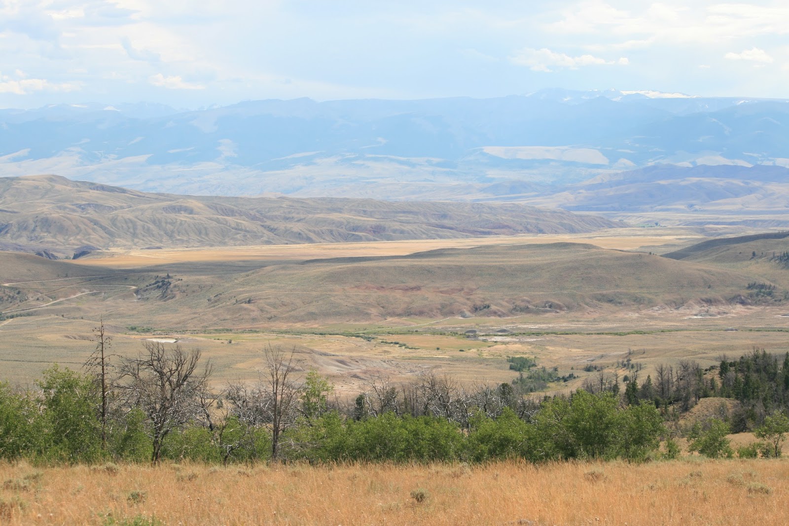
Born on the last day of 1932 in Buffalo, Wyoming; Joe was raised by a first-generation immigrant "mountain man" whose roots were firmly planted in the Pyrenees Mountains along the France-Spain border.  Joe's impressionable years occurred in the shadows of The Big Horn, where he began his lineage love for mountain life.  After reaching adulthood, he began his career with the Wyoming Highway Patrol.  He found the love of his life in his hometown of Buffalo, and soon thereafter made her his wife.  Children and countless trips to enjoy nature at higher elevations followed.  He experienced the joy of raising five children, and the heartbreak of burying two; recently commenting to Laura that he didn't want to bury any more of his children.  He had even mentioned to Laura over the past few days that he was ready to go home.  She told us she thought he was talking about Buffalo.

Earlier that morning, Joe and Laura took a walk to a nearby overlook behind their campsite.  After spending some time taking in the inspirational views, they returned to their camper and had an unremarkable lunch--their last meal together.  After lunch, Laura said she wanted to take a short nap.  Joe encouraged her to do so, stating that he wanted to take in the ridge-top view and capture some photos one more time.  He walked to the top, removed his shirt to let the sun warm his well-worn chassis, and sat on a nearby log.

When Laura awoke from her nap, Joe had not yet returned.  She thought he had tarried a bit much, but gave him a little more time before finally grabbing her hiking stick to go check on him.  When she reached the top of the plateau, she saw her husband of 58-years lying on the ground with his feet resting across the log he had been sitting on.  Joe had indeed gone home.

She carefully navigated her 82 year old body down the narrow, rocky path to the forest service road where she flagged-down a young man and his family from Gillette, who were camping nearby.  I would meet him later while making an apple pie transaction.  The next people to be flagged were Bill and his wife Sara.  With her nursing background, she summited the ridge and stayed with Joe until addition help arrived.  An array of emergency responders began to descend upon the camp shortly after our arrival. Johnson County Sheriff arrived first, with Forest Service Rangers and Buffalo EMS only a few minutes behind.

Bill and Kristy led the sherriff up to Joe's final resting place where Sara sat and watched over him.  Sara was relieved to have help, and get a reprieve from her vigil.  As the sheriff spoke to Sara, Kristy relayed how she marveled at the beautiful place Joe had chosen to perch.  The sunbeams pierced the forest canopy and bathed the log that would be his final resting place; a warm glow exuding peacefulness across the ridge.

Knowing how far each of these agencies travelled, and their arrival time since the 911 call was made, their trip up the mountain had to be a harrowing one.  As the other agencies arrived and exited their vehicles with great expediency, their sense of disappointment and sadness was visibly seen when they were informed that this was not a rescue, but a recovery.  Buffalo is a small, close-knit community.  Joe was no stranger to most of the responders.

The assembled responders made their way to Joe.  When they arrived at the ridge-line, they had a moment of quiet reverence as they stood on the stage where the final act of Joe's long life played out.  It was bittersweet, with the solemness of a passing soul blending with the inspirational surroundings that Joe had chosen as his last mortal view.  After performing agency-specific procedures, they respectfully covered him and carried him down from the ridge.  Unable to use a gurney, the 6-man team slowly made their way down the steep and rocky decline, reminiscent of a military casion team; while the pines and aspen stood at attention as Joe made his final descent from his beloved mountains.

Laura and their three dachshunds were at the camper.  She had a network of friends and family in Buffalo, but the non-existence of cellular service prevented her from engaging.  Vision problems rendered her incapable of driving, much less pulling a camper down the series of 8% grades.  With the EMS crew ready to take Joe to Buffalo, I offered to drive Laura and their camper into town.  Kristy and the boys would follow us.  After hitching up their camper, Laura and her hounds climbed into the Ford F-150 and we began our descent.  The truck didn't have an exhaust brake, so I drove slower than the posted speed-limit to reduce brake temperatures.  Although the trip was lengthy, she spent the time telling me about the life of her soul-mate; which I've tried to capture in this writing.

Just outside Buffalo she was able to make contact with long-time family friends.  They insisted she stay with them, so I drove the truck and camper to their ranchette.   Being part of the closing chapter of Joe and Laura's outdoor history was not lost on Kristy or myself.  With the truck and camper parked, and Laura physically in the presence of her network of friends and family, we departed.  She had a tough road ahead, but she was with Her People.  They would care for her.

Joe was born in the mountains; spent his youth in the mountains; got a job in the mountains; got married in the mountains; raised a family in the mountains; vacationed in the mountains; retired in the mountains; and died in the mountains.  His headstone my reflect a different surname, but we feel he lived a long and prosperous life as Joe Mountain.

wWw

Monday, August 24, 2015

Bighorn National Forest Boon-docking (WY)


As the sun wraps-up it's vitamin-D distribution for the day, the eastward-flowing shadows of The Bighorn Mountains converge at the crossroads of Interstates 90 & 26.  It is at this Great Plains junction that you’ll find the town of Buffalo.  What The Badlands failed to do to settler's spirits, this 80-mile long/30-mile wide/13,000+' high obstacle could bring a halt to further westward progress.  Being 19th-Century cowboy town, you'll find a much larger selection of Carhartt than Calvin Klein.  Our visit coincided with the annual county fair, but this wasn't the type of fair that featured carnival rides and stuffed animal prizes.  These folks focused on the important stuff: animal raising, canning, and ranching skills. You won't get a 36" Minion for popping a balloon with a dart, but you can get a years worth of braggin' rights if you can hang on to that bronc for 8-seconds or if your blackberry jam takes top honors.  Priorities...these folks have ‘em.  

The downtown area shows it’s 19th-Century beginnings and cattle-centric mindset.  Across from the city park—where bronze statues of cattle dogs herding sheep mark the entrance—the Occidental Hotel anchors the downtown, two-story skyline.  Like stepping back in time, this hotel has retained its early-western decor.  The vast array of antiques gives the first impression of a static museum; but this is a fully-operational hotel with full room, bar, and dining services.


Occidental Hotel lobby panorama
With our first boon-docking experience being a huge success, we were ready for more.   In keeping with the "scout firstcamp later" methodology, we pulled into the Buffalo KOA and established our scouting camp.  The Buffalo KOA is a nice campground that allowed us to flush our holding tanks, do laundry,  take care of any ordering or other personal business requiring internet connectivity.  It also gave us a short break from watching our fuel/battery/tank gauges.

First order of business was visiting the U.S. Forest Service office that oversees Bighorn National Forest.  The helpful rangers provided us with a detailed map similar to the one we used near Devil's Tower.  There was a slight modification to the rules-of-engagement, as the local Forest Service office had implemented a policy allowing dispersed camping only in existing camp locations.  What this meant for us was that we could only camp in an area that was already established as a camping pad and had a fire-ring.  We didn't anticipate this having much of an impact on us, as we were not interested in trailblazing or bushwhacking our rig into the next site.


Where to camp?  Meadow? Forest? Mountain?
Bighorn National Forest is a 1.1-Million acre multi-use government managed area in North-Central Wyoming.  Because of the sheer area that this forest encompasses, we didn't think that we'd have any trouble finding a place to boon-dockafter all, there was far less public land around Devil's Tower and we only saw one or two RV's the entire week we camped.  After leaving the strictly enforced 30 MPH Buffalo city limits speed limit, we began a series of 8-degree climbs into the Bighorn Mountains.  These are old mountains, with Precambrian rockformations dating back over a billion years—jutting out to frame the edge of the highway. 


Skeleton of a flume is all that remains from the Sourdough Creek timbering activities
About 20-miles into the journey we took our first scouting route: Sourdough Road.  This location was a huge focal point to local timbering activities over 100-years ago, and the remains of that infrastructure can be found amongst the vast undergrowth.  This gravel path follows (what else?) Sourdough Creek as it flows from the spring-fed elevations above.  We saw more established boon-docking sites in the first mile of Sourdough Road than we did our entire stay at Devil's Tower.  Unfortunately, we also saw more campers on these sites than we did our entire stay at Devil's Tower.  Finding a good spot might be tougher than we thought.


Buddy modeling his latest hair coloring: The Dirt Fade
Sourdough Road itself was in fair conditionwith only a few spots having teeth-rattling washboardingbut the spurs leading to the boon-docking sites were really bad.  Large rocks on the crest of the road; coupled with severely rutted-out tracks made me give pause before putting Hank's transmission case at risk.  The sites that weren't a challenge to egress were either occupied by fellow campers, or grazing livestock.  I have nothing against livestock...I have them over for dinner at least once a week.  The problem is that they have a tendency to leave evidence of their presence wherever they roam.  This does not bode well in a family with two dogs who are prone to wallowing in newfound turf.


Unknown roadside grave on Elgin Park Road
We found a few spots on Sourdough Road that were just okay, so we annotated our map and continued our search.  The next road was Elgin Park.  We have heard good things about this road through a boon-docking publication that we had subscribed to, so our hopes were still intact.  The first place we found was not a camping site, but a crudely constricted grave just off the road.  We had documented many cemeteries and graves during our cross-country travels, but this one was the most surprising due go its singularity and location.


Lots of boon-docking sites; and lots of boon-dockers
We continued down Elgin Park and were astounded at the number of campers that lined the main road and adjacent spurs.  We counted no less than 30, and that is just what we could see from the main road.  A trip down any side spur would reveal an additional dozen or more occupied campsites.  These people really loved to boon-dock!  As we exited a large strand of pines and approached the ridge-line ahead, we were graced with a magnificent view of the snow-capped mountain rangecomplete with a meadow of golden grasses spanning across the hillside.  We stopped in the middle of the road to take in this awe-inspiring view, as well as a few photo.  While I remained fixated on the view ahead, Kristy pointed towards my window and said, "Look! Campsites!"  WINNER! WINNER! CHICKEN DINNER!!!


Front yard view from our Bighorn boon-docking site
With our first-choice campsite selected, we returned to Buffalomaking sure to drive 30 MPH when we hit the city limits—and made our final preparations.  Anxious to spend some quality time in the solitude of the mountains, we completed our pre-flight chores much quicker.  The next morning we finished-up our departure checklist and rolled out to higher elevations.  With the sun beaming off the eastern Bighorn slopes, we made our assent up the steep grades.  A full measure of water, propane, generator gas, and recently purchases sundries had Hank was working all of his horses.  Although diesel engines generally perform better at higher altitudes than their gasoline engine counterparts, Hank was earning his keep on the 8% uphill grade while pulling the additional 500-pounds of drinking water.  

After crossing ridge after ridge, we arrived at our (thankfully!) vacant campsite.  The approach was steep enough to cause Glory to scrape her rear hitch on the road as we pulled onto the side spur.  We backed Glory into the campsite and checked for level.  It was difficult to see from with all the rolling terrain, but the site was badly sloping from left-to-right.  After several attempts to get Glory onto a left-right level spot, we noticed a small ditch a few feet away.  It was only about 4-6" deep, and 4-6' long.  The "Ah Ha! moment" arrived, and we realized some other 5'er owner had dug this depression to achieve the left-right  level that we sought.  When Glory's driver's-side wheels eased into the trench, the bubble on the level went to center.  Park It!


Kicking' it by the campfire under the lodgepole pine canopy
After a leisurely set-up, we parked our folding chairs on the front row of our spectacular view and again found ourselves in relative solitude.  The open view to the north and west allowed incoming light, while the rest of our site sat in the shade of Lodgepole Pines.  There was an abundance of seasoned and dry timber to keep the pre-existing fire-ring stoked.  Deer were frequently spotted a few feet from our perimeter, and elk were seen just a bit further back.  There was even evidence of moose activity in the aspen glade about 100-meters behind our camp; with an abundance of large droppings, hoof prints, and chewed bark.  The sunrises illuminated the mountain range, while the sunsets slowly melted behind the darkening contrasted peaks.  These spectacular views greeted us every moment, and we felt as though we were immersed amongst nature.  


Open Range Grazing: A place for every activity in The Bighorn
When the weekend arrived; the solitude, serenity and wildlife predictably reduced.  Caravans of trailers rolled down the dusty road en route to their weekend get-away.  ATVs sprinted up and down the road by the dozens.  We quickly learned that there are two primary seasons in the Bighorn: ATV and hunting.  During Spring and Summer, the majority of users are riding ATVs along the expansive trail network.  In the Fall and Winter, the focus shifts to hunting.

To ensure that everyone is afforded opportunities to respectfully utilize our public lands, the Forest Service hires seasonal rangers to assist in managing the various interests and activities within the forest.  These interests and activities include: dispersed camping, hunting, fishing, trail hiking, motorized and non-motorized trail riding, livestock grazing, timbering, and geological/archeological research.  Keeping all of the aforementioned groups playing nicely together on the same piece of land is a full-time job.  


Miles to explore: A ribbon of road bisects fields of gold
Even with the dramatic influx of weekend activities within the forest, we spent enjoyable days hiking around the immediate area, or exploring the vast web of backroads that provide access across this vast forest.  We found a few roads that took us to tremendous views and wide-open spaces that provided breathtaking views and the solitude of nature that we were seeking; while other roads led to kidney-bruising dead-ends.  Regardless, the hours of exploring this vast, (mostly) unspoiled wilderness was a vacation unto itself. 


Thanks for the warning, but...we're here for the adventure.
One of our exploration trips was down "Crazy Woman Trail."  This narrow and rock-laden road wad a real kidney-bruiser under Hank's ultra-stiff suspension.  We traveled several miles until we decided the views were not worth our fillings being rattled loose.  About halfway back, we were stopped by a guy on a Harley.  He asked usin a very European dialectif it was okay to drive a motorcycle down this road.  I told him it was legal, but it might not be the best idea if he wants to preserve his kidneys or paint job.  We took a brief detour and then continued to the entrance of "Crazy Woman Road."

When we arrived at the intersection, the guy on the Harley was there with a group of other motorcyclists.  All of them had patches on their jackets that identified them as Swedish Hog Riders.  This group had obviously traveled a long way to take part in the 75th Sturgis Rally, and we're now a days ride away from the American Motorcycle Mecca. They were all dismounted and looking around at the scenery, so I quickly accessed all of my Swedish phrases I was taught in grade school and gave them a hearty and welcoming, "Bork, Bork, Bork."  The eldest gentleman approached an told us they were looking for moose and asked if I knew where they could find some.  I relayed to them that we had not seen any, but there were river areas that were more prone to moose activity.  I also informed them that (moose) cows can be very dangerous when accompanying their calfs, and to make sure you give them a wide berth when photographing.  Above all, do not approach or try to pet them.  This information seemed to be completely “foreign" to them, and the older guy relayed to the group the info I had presented.  They all gave the universal, “we had no idea" look, and continued to talk amongst themselves.  Still not sure why they were looking for a moose, but I suspect it involved some unusual Swedish cuisine.


Suddenly, a young woman in their group pointed at some objects on the distant ridge-line.  She had the entire groups attention as she pointed at the distant, dark objects that were barely moving.  I grabbed my binoculars and walked to her vantage point.  As the group pointed and pontificated whether it was moose, antelope, or deer; I focused my lens and clearly saw...the tops of aspen trees gently swaying in the wind.  The group awaited my proclamation as to which North American species they were witnessing in its natural habitat.  I told the older guy, "Trees."  He initially looked puzzled, then looked through my binoculars and laughed.  He then informed the group that it was merely tree tops swaying in the wind.  

The younger woman was slightly embarrassed, and was catching some ribbing from her fellow travelers.  Never passing up an opportunity to haze a citizen from a neutral country, I turned to her and said,"Not dangerous. You can pet them."  NOW she was thoroughly embarrassed, as her companions increased their roasting of her.  I offered them some bottled water; thanked them for their utilitarian knives, accurate watches, tasty meatballs, soothing massages, and attractive bikini team; and gave them another hearty "Bork, Bork, Bork."  If Sweden ever declares war against us, I'm taking credit.  
“I see my path, but I don't know where it leads. Not knowing where I'm going is what inspires me to travel it.” -- Rosalia de Castro

wWw

Saturday, August 22, 2015

Devil's Tower Boon-docking (WY)

"Be getting' over, till the Big Sky Country; We be kissing' time, be kissing' time goodbye." ~ Chris Whitley; Big Sky Country

Confident that we had enough infrastructure and experience, Kristy and I began preparations for our top-shelf goal--boon-docking.  Boon-docking--also known as "dispersed camping" by the U.S. Forest Service folks--is the practice of setting-up your camp on public lands.  This create-a-camp methodology requires the camper to bring ALL of the infrastructure and basic needs that are commonly found inside traditional campgrounds.  It also means that the dispersed campsite will likely be a rough, unimproved piece of land that may pose significant access and RV leveling challenges.  These two challenges are the reason scouting is such a vital task, and why we opted to utilized the nearby Reuter campground.

With the recently acquired U.S. Forest Service map in-hand, we climbed aboard Hank and began our scouting adventure.  The map is similar to most, with the exception of small dots lying adjacent to existing roadways, signifying where approved dispersed camping areas are located.  The good news was that there seemed to be hundreds of dots covering the map--giving us a wide selection to choose from.  The bad news was that dispersed camping also includes hikers carrying a one-person tent in their ruck.  We'd need a little more acreage to accommodate Glory's massive footprint.

The rules are fairly simple.  Find a location that is approved for dispersed camping, and set-up your camp within 300' from the center of the road; and don't stay more than 14-consecutive days in that location.  This means that you can actually camp on the side of the road as long as you do not impede the flow of traffic.  This may seem like an easy solution, but it would be a bit unnerving to awake to 4-wheel drive headlights racing towards the bedroom slide that protrude towards the edge of the roadway.

Our plan was simple: start driving backroads.  The first road we explored was a gravel passage that wound through the adjacent hills, varying in width as it made its way through the forest.  Our roles were vastly different, but equal in importance and necessity.  While Kristy was peering up to 300' into the adjacent woods looking for potential campsites, I was imagining pulling Glory down this rocky path.  With every "ooh" and "ahh" that the scenery invoked from Kristy, there was a matching "ooh, that's a tight turn with a 20' drop-off" and "ahh...think that tree branch hangs a bit too low."  

We found a side road off the main side road that looked promising.  The map had this road leading to a hill-top outcropping with elevated views towards the east.  The road was narrow, but navigable...for a short distance.  The rough and rocky road quickly became a two-rut pathway that was littered with large rocks and crowded by trees and stumps.  We proceeded to the terminus where we found the beautiful overlook that the map had accurately displayed.  We also found a few things that weren't on the map: a make-shift camper that may or may not have been occupied; and no place to turn around.  This last finding really drove home the importance of scouting, as backing an RV down the path we'd just travelled would've been virtually impossible.  I put Hank in reverse and we began our slow retreat through the rocks, stumps, and trees.  We eventually found a very small clearing where--with Kristy as an outside spotter and Hank in 4WD--I was able to make a 12-point turn-around.  

Emil Reuter: Pioneer, Prospector, Hermit & Local Legend
For a moment I was getting discouraged.  If that last site was what the "average" boon-docking site looked like, we're probably going to be hanging out in developed campgrounds.  The next road was wider and not so tree-laden; but it didn't have any sites that we could get Glory into.  It did have two interesting features: an abandoned gold mine, and the grave of Emil Reuter--a famous prospecting hermit who lived in the nearby hills and whose name adorns the Forest Service campground where we were staying.

Walker Campground; Black Hills National Forest
We jumped back on the paved thoroughfare and kept moving northward.  At Bear Lodge Mountain--site of the USFS fire tower--the pavement abruptly ends.  We pressed onward for another mile and decided to take a short side road and give The Boys a little run-around time.  At the top of this side road was a big...level...mountain-top...gravel pad. Once the site of a radio transmission tower, this abandoned tract had 360-degree views and a 15' concave berm that blocked the strong northwesterly winds.  The western slope was covered in native grasses--an ideal spot for observing grazing wildlife; and the northern slope had an unobstructed view of Devil's Tower--fifteen miles away.  J-A-C-K-P-O-T!!!

We returned to Reuter campground and made preparations for our off-the-grid journey.  After emptying our tanks (for a small fee) at a RV park in Sundance, we filled our 70-gallon fresh water tank and headed to our remote and exclusive campground.  With an abundance of space, Hank easily pulled Glory onto a level area adjacent to the berm.  After a routine set-up and deployment of "Three Mile" and "Chernobyl"--our twin Honda Power Plants--we sat on the top of Our Mountain and took in Our View.  The Dream had become reality.

Darkness envelopes Devil's Tower behind a lava-red sunset
From Walker Campground we set out on daily drives to further explore the Black Hills  National Forest (WY), and of course...Devil's Tower.  Instead if taking the Devil's Tower tourist highway (US 14), we opted for a leisurely trip through the backroads that traversed both public and private lands.  The scenery was spectacular, and we were able to stop Hank at any place we wished to capture these memories.  

Scenic backroads to Devil's Tower
Designated as America's first national monument in 1906 by President Teddy Roosevelt, Devil's Tower received a boost in notoriety as the UFO airstrip in the 1977 Steven Spielberg movie, "Close Encounters of the Third Kind."  This monolithic monument is also sacred amongst the Native American population, with the creation of the tower being a part of tribal lore. 

Classic Devil's Tower; Western slope in full afternoon sun
Walker Campground served as our bed-down location for six wonderful nights; enjoying the scenery, solitude, and sunsets.  Well...five were wonderful.  The one thing missing from Walker Campground is a reliable cellular signal. Without a strong signal, we are mostly blind to any weather conditions that may spawn during the night.  On one such evening--predictably around 2 AM--I was awoken by shaking and paparazzi-like light flashes.  The shaking was being generated by Callie--who had relocated his astraphobia-rigors to the safety of my pillow; and the light flashes were from a continual lightening event that was passing dangerously close overhead.  

Massive thunderhead illuminates the evening sky as it prepares to illuminate the late night sky.
One of the many benefits of camping on top of a mountain is that you have an unobstructed view of the lightening as the clouds pass through your camp.  I grabbed my iPhone and saw that it could only muster 1-bar of service, with an occasional leap into 2-bars.  I opened up my "go-to" weather app--Storm--to see if I could get any info on the blinding light show that was transpiring around us.  Storm loaded up the radar, and it appeared to be just an all-purpose thunderstorm passing by.  I relayed this to Kristy, and told her that it should pass without issue in about 15-minutes.  

I retrieved the weather radio to see if any additional information could be gleaned.  Upon my return to the bedroom, I found that the Storm application had received enough data to update the very outdated radar that I had previously viewed.  We now had a severe thunderstorm with 60-MPH winds and the possibility of damaging hail five minutes away.  The 60 MPH winds were of concern, as the Forest Service employee at the fire tower informed us that winds "up top" are normally 20 MPH higher than what the weather service reports for lower elevations.  We were now faced with the potential for 80 MPH winds and hail only monuments away.  

After informing Kristy of the impending weather, we decided to seek better shelter.  Being no strangers to bad weather on this trip, we have a "bug-out bag" at-the-ready for such events.  We grabbed our essentials and tried to coach The Boys out of the trailer.  The lightening was intense and there was no need for a flashlight, as the habitual flashes in the low-hanging clouds overhead kept the mountain-top area well lit.  Begrudgingly (and probably a bit confused considering the outside weather), The Boys exited Glory and jumped into Hank.  We really had no place to go, but knew 1) we didn't want to be completely exposed on top of the mountain; and 2) we didn't want to be next to anything big (i.e. Glory) if the winds decided to start "moving things around." 
"I went down to the crossroads, fell down on my knees.  Asked the Lord above for mercy, 'Save me if you please.'" ~ Robert Johnson; Crossroads
The road in front of our campsite traverses down to lower elevations and into a denser forested area.  We headed to lower ground, hoping that the trees would provide some reprieve from the wind and hail, but also realizing that they could be a hazard if the wind starts blowing them over.  We drove to an intersection of Fort Service roads, parked off to the side, and waited.  And waited.  And waited.

After midnight.  Alone on a desolate dirt road.  Waiting at the crossroads.  Devil('s Tower) nearby.  Robert Johnson would be proud.

Using our best guestimation, we waited for an hour as the winds and rain increased and then tapered off.  We headed back up to Walker Campground, hoping that any damage to Glory would be minimal.  With the exception of our front patio mat being wrapped like a scarf around Glory's front landing gear, there was no damage whatsoever.  We watched the storm as it continued eastward--with the continuous lightening illuminating the massive cloud formation--and a clear, star-filled sky in it's wake.  Confident that the danger had passed, We hauled our tired bodies back inside and quickly fell asleep.

The weekend came and we were fortunate to visit with The Hayes family for the 4th time in as many weeks.  It was great to sit on top of our private retreat and break bread with such great friends.  I had built an in-ground fire-pit at the apex to enhance the sunset experience, but the reliably constant Wyoming winds kept us from christening the newest campsite feature.  We again said our goodbyes and prepared ourselves for the move.  

Kristy & The Boys watching The Dream become Reality
Our first attempt at boon-docking was a great success; and it whetted out appetites to seek-out additional dispersed camping opportunities.  More bad weather was rolling in.   The storm-front with its curtains of precipitation were clearly visible from our mountain-top retreat, and it was rapidly closing in on us.  The wind increased to where I could not keep my sunglasses on my face.  We broke camp with great expediency and drove westward through high winds and spawning storms.  After a long day of battling headwinds that kept Hank averaging a meager 8 miles-per-gallon, we arrived at our next scouting camp: Buffalo, Wyoming and the eastern gateway to The Big Horn.

wWw