Thursday, October 15, 2015

Sinks Canyon State Park (WY)

The Essential Sinks Canyon
With the chocks set and the utilities connected, we prepared for a few days of on-the-grid living in Lander, Wyoming.  Lander is a quaint town that has the feel of an upscale town.  The downtown area has retained the historical look, and the overall appearance is clean.  Since we had been boon-docking for a while, we needed to stock-up on a few things and this town would do the trick.  

Lander wasn’t on our original list of places to visit, but it did offer a comfortable stop-over between The Bighorn and our planned destination of Yellowstone.  Although our main focus was to head towards The Tetons, we thought we’d kick around this area and see what hidden gems we could find.  The previous 150-mile trek from the northeast had revealed mountains, canyons, dinosaur remains, and thermally driven natural hot springs.  Certainly this area had something that was notable.  We were not disappointed.

Lander sits at the southeastern end of the Wind River Mountains.  This mountain range is perhaps perhaps the most “unspoiled” area in Wyoming—to include Yellowstone.  We headed about 5-miles southeast of Lander to the Sinks Canyon State Park.  This park would be a destination anywhere east of the Mississippi River; however, with competition from nearby Yellowstone National Park and Teton National Park, it remains rather obscure.  That obscurity is a blessing to those who happen to stumble upon it.
Kristy & Buddy scouting the flora below the vertical cliff walls
From the moment you enter the steady uphill grade into the park, you are bordered by high cliffs of sedimentary rock firmly planted on a bed of granite.  These vertical cliff walls—terminating at amazingly horizontal plateaus—bring immediate images of western films where “indians” would line the high-ground cliffs prior to descending into battle on the valley floor below.  This was natural western nostalgia at it’s finest.

Popo Agie River cascading downwards and into the mountain-side "sinks"
One of the most interesting features of the park—to the point of being referred to as a “geological phenomenon”—is the “Sinks” and “Rise.”  From high within the mountains, the PoPo Agie (translated from the Crow Tribe as “gurgling river”) River flows down through the rocky, juniper and sage-laden landscape, and disappears into the side of the mountain.  Geologists have yet to map the exact course of the river as it makes its subterranean trek; but all evidence of river activity is void until it reemerges a half-mile “downstream” at pool that is currently home to hundreds of obscenely large trout.  The disappearance into the mountain (“sinks”) and reappearance at the trout pond (“rise”) is what gives this feature its name.
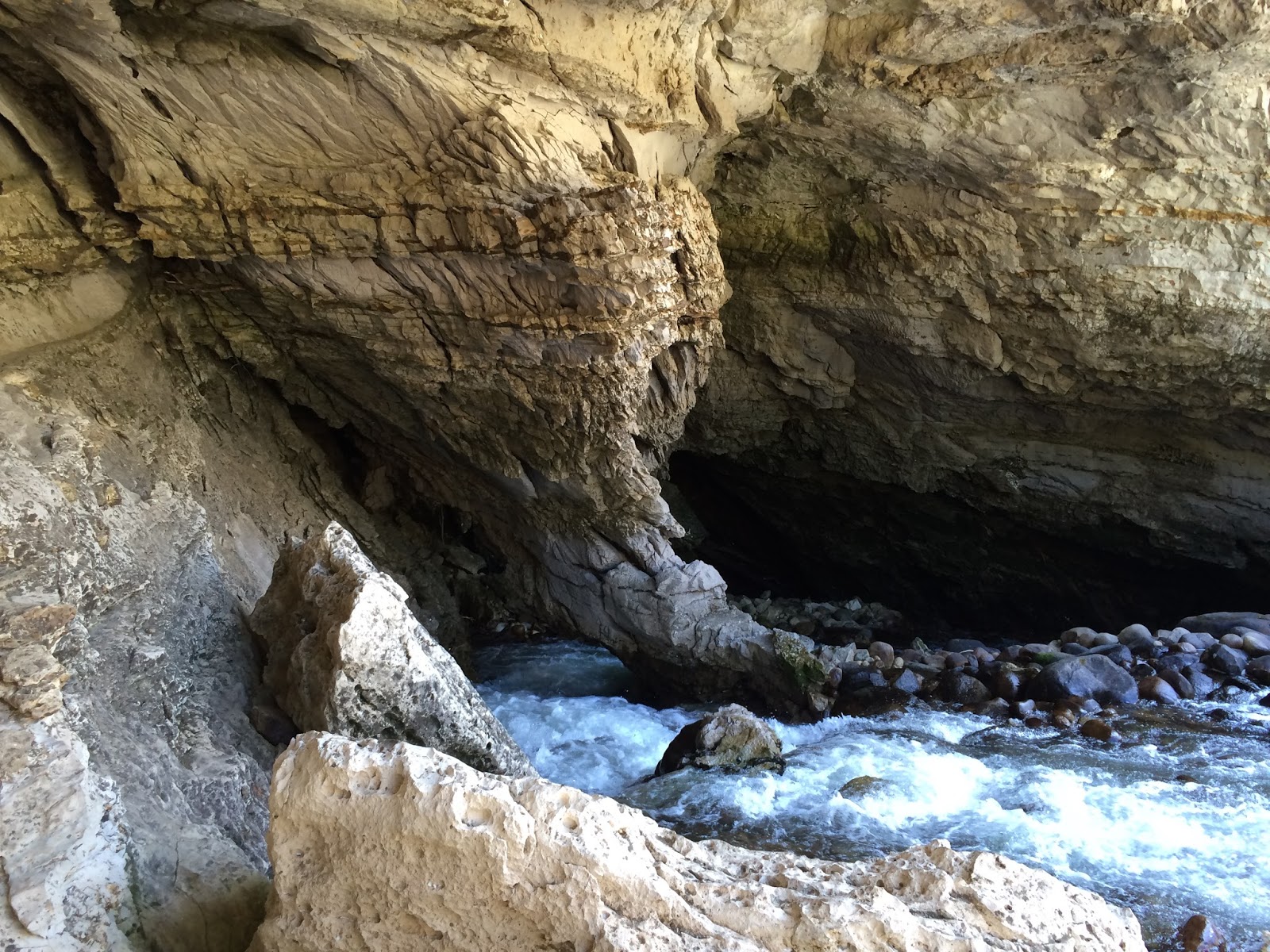
The Popo Agie River "Sinks" into the mountain-side...
...and reappears 1/2-mile away at the trout pond.
A few miles uphill from the Sinks and Rise sits Bruce’s Picnic Area; named after John Bruce, one of the earliest forest rangers in this area.  Bruce’s Picnic Area marks the trailhead for the Middle Fork Falls, a 1.5-mile trail that ascends 600-feet to the base of…a high desert waterfall!  With Kristy’s affinity for hiking and waterfalls, our plans were seemingly preordained.  

A herd of "Trout-zillas" frolicking in the "No Fishing Zone" at Sinks Canyon State Park
We parked in the adjacent lot, strategically jammed water bottles in cargo pockets, secured The Boy’s leashes and headed up the trail.  The pathway was rocky and dusty--a by-product of the incredibly arid environment that lay around us—and paralleled the Popo Agie River for the 3/4-mile.  These were really at contrasting opposites; with the powdery soil seemingly unaffected by the forceful river running closely adjacent.  The trail continued upward; increasing in both pitch and elevation.

Halfway up the Middle Fork Falls Trail
Although we had driven across (what looked like) relatively level terrain during our trek into Lander, we had actually been gaining significant elevation all along the way.  Lander was a “really flat” 5,400' in elevation; with the Sinks Canyon Park entrance around 6,500’.  The trailhead of the falls had us starting our hike at 7,150’, and by the time we hit the switchbacks (roughly 7,500’) we were reminded that we were “oxygen junkies.”

After slowly and steadily motoring through the switch-backs, we made our last push to the base of the falls.  Streaming down over a series of cascades, the Middle Fork Falls display their crescendo moment over a 60’ drop.  The trail continues to the upper falls area; where hikers, climbers, horseback riders and fly fishermen enjoy their favorite activities in a mountain top surrounding.

Wes & Callie taking in some views, air, and water
We tarried long enough to snap a few photos, hydrate ourselves and the hounds, and oxygenate our cells.  The sun was dipping behind the westward ridge-line and we needed to give ourselves time to hike while the light was still favorable.  The hike down was easier on the muscles, but harder on balance.  The dusty surface did not provide much of a footing for the imbedded rocks, and the ground had a tendency to give-way when you least expected it.  By the time we reached Hank, we were ready for a “dust-cutter” ourselves.  

The park was truly a diamond-in-the-rough on an out-of-the-way destination.  We appreciated both the accessibility that the well-maintained trails provided; as well as the restraint of development and keeping the park in a very natural setting.  We later found that this was the mantra of the park development plan form the very beginning: "Within the canyon walls are found unspoiled symbols of the best of Wyoming. The mountains, the river, the fish and wildlife; sage, wildflowers, aspen and pine trees, a rugged country of tranquil quiet under blue sky. The development of park facilities must accent and enhance these values. To overwhelm them with chrome plated campgrounds and concession stands would be unwise.”

Well done Lander.  Well done.

wWw

Saturday, October 10, 2015

Bighorn Basin’s Greatest Hits

As we planned our westward exit from The Bighorn, we took a look at the travel atlas to see what was a plausible destination.  We were planning our approach into Yellowstone, and the two routes that presented were towards the western entrance via Cody (190-miles), or towards the southern entrance via Dubois (270-miles).  For reasons that completely elude us to this day, we choose the longer route that took us through some of the most unrecognizable names in Wyoming.  

We broke camp from our Bighorn boon-docking site and headed westward on 16.  The day was overcast and the temperature bottomed-out at 46F when we reached the 9,685-foot pinnacle of Powder River Pass.  The western departure from the Bighorn did not provide any driving breaks as the eastern side did with its series of descents and plateaus.  The next 10-miles of driving would be an intense 8% grade with a double-hairpin switch-back at the halfway point.  Even with the transmission in a lower gear, and Hank’s exhaust brake singing baritone all the way down the mountain; we had to make an unscheduled stop at a pull-off to let the brakes cool down.  

Beyond the double-hairpin switch-back the road began to level to a manageable grade, as we rolled through the sheer canyon walls bisected by Ten Sleep Creek.  As the towering canyon walls began to shrink in size, the horizon ahead began to open up and the moderate cliffs began to show more variety in colors.  

We continued to follow the river trail—littered with sporadically parked vehicles of fly fishermen hiking down to their favorite spots—and arrived at Ten Sleep.  Ten Sleep is a small town of less than 300 and was a Native American rest stop during travels across this region.  It derives its name from the fact that it is 10-days travel—or “10 sleeps”—from this location to Fort Laramie, Yellowstone National Park, and the Indian Agency on the Stillwater River in Montana.

The geography made a sudden change, with the rocky granite being replaced by colorful worn clayish cliffs that were very similar to those across The Badlands.  With the exception of a large mountain range to our east, we could’ve easily mistaken this area for The Badlands.  This stretch of colorful pastel land continued for several miles until we crossed Big Cottonwood Creek—and suddenly it was like watching The Wizard of Oz backwards.  The pastel colors changes to dull beige with an erratic pattern of sage across the ever-flattening hills.  The horizon became increasingly large, with the largest natural shadow coming from solitary cedars making infrequent cameos.  The predominant structures were miles of power-lines extending into the barren landscape and oil wells.  This was a dusty, deserted land that would’ve been an excellent option for filming the Mad Max trilogy.

After several miles the dusty wasteland abruptly disappeared and was replaced by lush green fields of corn and sugar beets.  We had arrived at Worland.  Worland is a town of around 5,000 who make their living off oil and sugar beets.  The Bighorn River runs to the west of Worland, and if “Egypt is the gift of the Nile,” then “Worland is gift of the Bighorn River.”  The lush greenery that extends to the municipal limits sits directly in the shade of a vast network of irrigation systems.  Without this irrigation network, Worland would look like the previous 10-miles.  Probably the most unfair feature of Worland is the weather.  The summers are hot and dry, with the average high in July of 89F (record: 107F) and the average low in January of 3F (record:-50F).  There is no month where the average temperature is between 70F-80F.  Extreme living indeed!

Unable to continue westward (as the highway abruptly became a north/south option), we merged onto Route 20 and followed the Bighorn River.  The Bighorn River is a large river that enables this region to have a sustainable agricultural presence.  The long green ribbon of cropland that borders both sides of the Bighorn River provides a contrasting reprieve from the distant arid plains where irrigation has yet to reach.

After another 30-miles of southward travel we arrived at the town of Thermopolis.  Thermopolis is home to the world’s largest mineral hot spring—and unlike other “hot spring” tourist traps—this one is 100%, absolutely free.  They even have a big city park where you can soak your bones in the natural noodle bowl.  It is such a large hot spring venue that it appears to be a type of water park when entering the city from the north. With the geothermal activity bringing steamy water to the surface, and rare dinosaur artifacts discovered nearby; this place must have been really rockin’ at one time.
The Green Belt ends and the Wind River Canyon begins
With 90-miles of travel behind us, we were ready for another drastic change in the scenery; and we got our wish.  Upon departing Thermopolis, we entered the Wind River Canyon area.  This aquatic juncture—known as “The Wedding of the Waters”—is where the Wind River becomes the Bighorn River; and it serves as the eastern border of the Arapahoe & Shoshone Reservation.  The Wind River is a fast-flowing white-water river bordered by lush vegetation and steep cliffs that wind through this very windy gorge.  The highway parallels the twisting river, and in some instances goes through the adjacent mountainside.  These cozy tunnels with arched tops and a paucity of shoulder space made everyone momentarily cringe as we squeezed Glory through these narrow and unmovable passages.  One of the most impressive sights along this route are the enormous “house-sized” boulders that sit in the middle of the Wind River.  They look completely out of place until you follow the trail of scree that follows towards a place in the mountain where a large cavity now exists.  In some of these areas you can see where the highway and adjacent railroad track have been recently repaired due to the monstrous-sized boulders bring total destruction from above.  To witness an event such as that must have been both jaw-dropping and pant-staining.

Giant boulder (just right of roadway marker) rest in the Wind River
Nervous navigation through mountain tunnels
As we followed the Wind River, we came to another abrupt geological change.  The canyon opened-up to reveal a large body of water that was surrounded by a high desert plateau that stretched into the horizon.  The large body of water—Boysen Reservoir—was the result of damming the southern end of the Wind River Canyon.  Again we were looking at relatively flat terrain speckled with sage, except now we had a 300-Million gallon pond to our west.  

We followed the arrow-straight rolling highway to the crossroads of routes 20 & 26, where sits the small town of Shoshoni.  Shoshoni warrants a dot on the map—but not a large one.  The 2010 census listed the population at 649; 45 more than the census of 1910.  It is a very old town that has not had a make-over…well…ever.  .  The summers here are hot, the winters cold, and the rain scarce.  You gotta admire the moxie of folks who live in such extreme conditions and still seem to enjoy life.  Somebody should bottle that.

Twenty two boring miles southwest of Shoshoni is the “rendezvous" city of Riverton.  I’m unclear as to why the governing body decided to describe this city of 10,000 that is equidistant from any big city as “the rendezvous city,” but it sure does sound…French.  It is a large enough city to warrant its own Walmart, and with only 12 stores in the entire state of Wyoming…I guess that says something.  We considered Riverton as a bed-down site for two reasons: it had a westward road towards Yellowstone; and we were tired of traveling.  Unfortunately it did not have any RV parks that were favorably rated, so we grabbed a bag of road food, fueled Hank, and continued towards southwest.

South of Riverton our road narrowed and changed numbers to 789.  Another Fifteen miles southwest and we had reached the “small dot” town of Hudson.  As we drove down the 4 blocks that make up the main drag, we passed Svilar’s Bar and Dining Room.  We would later find out that the best ribeye steak for miles around are served at this establishment.  Although we didn’t dine there, that claim is believable based solely upon the number of cars in the parking lot and along the street.  Apparently the entire 400-person population of Hudson was dining there that night.  Across the street from Svilar’s was the Union Bar.  I don’t pay a lot of attention to small town bars, but this one was surrounded by 6-foot chain-link fencing that was topped with razor wire.  I’m not exactly sure what goes on inside this establishment, but I'm guessing you better bring your "A-Game" when you step through that door.  Since my "A-Game" is currently in temporary storage in Victoria, Texas, we just kept driving.

It had been a most unusual travel day; a day that proved to be the most interesting driving day to date.  We started in the high mountains; traversed steep gorges; rolled through Badlands-type terrain; crossed through desolate and dusty oil country; trekked through sugar beet fields; witnessed geothermal hot springs; navigated narrow tunnels and white-water adorned with boulders; rode the high plains beside gigantic reservoirs; saw one of the dozen Walmart's in the state of Wyoming; and found a place to get a great steak and a fist-fight.  The town of Lander lie 10-miles ahead.  We found a small road-side RV park with full hook-ups and settled in.  Since we had been boon-docking for awhile, we needed to stock-up on a few things and were curious to see what hidden treasures we could find in this out-of-the-way town.

wWw